Villiers Island Flood Protection and Cousins Quay: What to Know Before You Comment
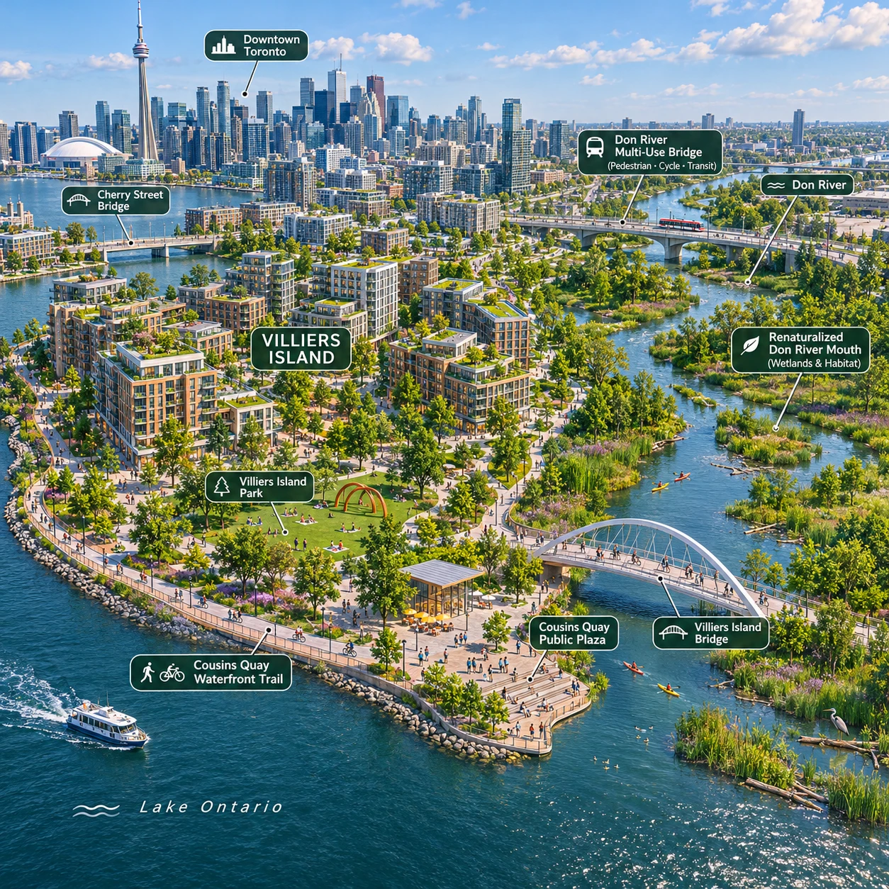
Villiers Island is being shaped by two closely connected goals: reducing flood risk in Toronto’s Port Lands and creating a new waterfront neighbourhood with public spaces and trail connections. Cousins Quay is part of that larger vision, though the details of individual developments and public-realm designs can change during approvals.
If a proposal is open for comment, the most useful place to start is its application notice and City review materials. They identify the applicable submission method and deadline, and help you connect your feedback to the actual plans.
Why Villiers Island needs flood protection
Villiers Island needs flood protection because parts of the Port Lands have historically been vulnerable to flooding from the Don River and Lake Ontario. A flood-protection landform and new river valley are designed to manage that risk while making room for a neighbourhood and public access.
In plain language, a flood-protection landform is raised and shaped ground that helps keep floodwaters away from developed areas. It works as part of a broader system, not as a guarantee that flooding can never happen. The design must account for how water moves through the landscape, where it can safely flow, and how streets and buildings connect to protected ground.
The Port Lands plan links flood protection with new parks, streets, housing and waterfront routes. That connection matters: development depends on suitable protection, while the landform and river valley also create the structure for public space. The trade-off is that a large engineering project takes time and careful coordination, and the finished landscape may differ from early illustrations as detailed designs and approvals progress.
How the landform and Don River renaturalization work together
The flood-protection landform and Don River renaturalization work together by giving river water a planned route and creating higher, protected areas around it. The river valley provides space for water to move; the landform helps separate that water from places intended for development.
The Don River mouth was reconfigured as part of the Port Lands flood-protection project. Instead of treating the river as a narrow channel that must be held in place by conventional barriers, the approach creates a more naturalized river valley with room for flows and habitat. New and reshaped landforms help define the edges of this system and support access to the surrounding waterfront.
This approach can provide ecological and public-realm benefits alongside flood management, but it does not remove every hazard. Extreme weather, changing lake levels and the limits of any engineered system still matter. For project details and current information, consult the Toronto and Region Conservation Authority’s Port Lands information. The TRCA has a role in conservation and flood-related review; the specific approvals involved depend on the project and its location.
What Cousins Quay and the waterfront trail may look like
Cousins Quay is planned as part of a connected waterfront neighbourhood, with public spaces and routes intended to link the water’s edge to streets, parks and the wider Port Lands. The exact layout and features should be checked against the current plans for each project.
Plans for the area may include a waterfront trail, boardwalk sections, gathering spaces and connections across or alongside the river. Bridges, including the Cherry Street bridges built as part of Port Lands infrastructure, are important for access between districts and for linking walking, cycling and street networks. Those connections are also relevant to the future movement of people through Cousins Quay.
The trail is meant to address gaps in the broader waterfront route, but the whole network will not necessarily open at once. Construction sequencing, adjacent development and infrastructure work can affect when particular sections become accessible. Look for details on trail width, crossings, accessible routes, seating, lighting and separation between walking and cycling where these are shown in public-realm materials.
Plans may also include parks and spaces near the water, with planting and shoreline treatments intended to support both public use and ecological function. A rendering is an illustration, not a construction guarantee: ask whether a feature is approved, proposed or still under review.
How development applications connect to the wider Port Lands vision
Toronto development applications translate the broader Port Lands vision into proposals for specific sites. Depending on the project, an application may seek zoning changes, site plan approval or changes to official plan policies.
Each application sits within a wider framework that includes flood protection, the Don River valley, transportation, housing and public space. A planning rationale explains how the applicant believes a proposal fits applicable policies. It is useful evidence of the applicant’s case, but it is not the City’s final assessment.
For Cousins Quay, this means a building proposal may affect more than its own site. It can influence trail connections, views, public access, street design or how a development meets neighbouring parks and waterfront spaces. Focus on the parts that the application can reasonably address. Larger infrastructure or flood-protection decisions may be managed through separate approvals and project processes.
How to find and comment on an application
To comment on a Toronto development application, find the application’s official notice, confirm its deadline and submission channel, then send focused feedback through the method the City specifies. Requirements can vary by application, so the notice and City materials are the authority.
- Identify the application. Use the address, application number or project name in the notice or City planning materials. Make sure you are reviewing the right site and proposal.
- Check the deadline and method. The notice may provide a planner’s contact, an online form, a meeting registration process or another route. Do not assume a general comment portal applies to every file.
- Read the plans and staff materials. Review what is proposed and which parts remain under consideration. Note the document date, since plans can be revised.
- Write a concise submission. Identify the application, state your concern or support, and point to a specific plan, policy issue or public-space outcome.
- Keep a record. Save your message and any confirmation. If you want to speak at a meeting, follow the registration instructions and timing in the notice.
Public consultation can include written comments, meetings and notices to nearby residents or other interested parties. Feedback may inform staff analysis, revisions or conditions, but submitting a comment does not guarantee a change or determine the final decision.
What to review and how to make feedback useful
Before commenting, review the planning rationale, site plans, elevations, landscape plans and any relevant City staff report or public meeting notice. Useful feedback is specific, tied to the application and clear about the outcome you are asking the City to consider.
When reading a planning rationale, check what policies the applicant cites and whether the proposal’s details support those claims. For a waterfront project, useful questions might include: Is the public route continuous? Are crossings understandable and accessible? How does the proposal connect to nearby parks, bridges and streets? Are public spaces clearly distinguished from private areas?
For flood-related concerns, refer to the drawings and documents that address grading, drainage, river edges or approvals. Avoid assuming a development application can change the overall flood-protection system. The TRCA and City may have different responsibilities, and the application notice should indicate relevant review pathways.
- Describe the location or feature you mean, such as a trail crossing or park entrance.
- Explain the practical effect: for example, a route that appears to end at a site boundary may weaken trail continuity.
- Ask for a realistic response, such as clarification, a design adjustment or further study.
- Separate verified facts from questions or concerns, and cite the drawing or page when possible.
Broad statements such as “the project is too big” are harder to assess than a clear concern about a specific height, access point or public-realm connection. Planners can evaluate precise comments against policies and technical materials, even when they cannot resolve every issue through that application.
Frequently asked questions
Where can I find the deadline and submission method?
Check the application notice and the City’s materials for that file. They state the relevant deadline and how to submit; do not rely on a deadline from another application.
What documents should I read before commenting?
Start with the notice, site plans and planning rationale. Then review any landscape or transportation drawings, staff report and meeting information relevant to your concern.
Does commenting guarantee a change to a proposal?
No. Comments help inform the review, but they do not guarantee a revision or a particular decision. Staff consider feedback alongside planning policy, technical review and other evidence.
Who reviews public comments?
City planning staff generally consider comments relevant to the application and may summarize issues in a report. Depending on the approval pathway, a committee or council may make a decision; agencies such as the TRCA may review matters within their authority.
Villiers Island’s flood-protection landscape, Cousins Quay and the waterfront trail are connected pieces of a changing Port Lands plan. If you comment, anchor your feedback in the current application documents, explain the specific outcome that matters to you, and submit it through the channel and by the deadline stated in the official notice.